| Atmospheric Cloud Taxonomy & Microphysics | |
|---|---|
| Scientific Discipline | Nephology |
| Initial Framework Creator | Luke Howard (1802) |
| Primary Regulatory Body | World Meteorological Organization (WMO) |
| Fundamental Mechanisms | Adiabatic Cooling & Aerosol Nucleation |
| Cold Precipitation Model | Wegener-Bergeron-Findeisen Process |
| Warm Precipitation Model | Collision-Coalescence Process |
| Total Principal Genera | 10 Mutually Exclusive Genera |
| Highest Altitude Formation | Noctilucent Clouds (85 km) |
| Major Anthropogenic Cloud | Cirrus homogenitus (Aviation Contrails) |
| Wildfire-Induced Storm | Pyrocumulonimbus (PyroCb) |
| Dry Adiabatic Lapse Rate | 9.8 °C per kilometer |
| Pure Water Freezing Point | -35 °C (Homogeneous Nucleation) |
| Official Taxonomic Guide | WMO International Cloud Atlas |
The Earth’s atmosphere is a ceaselessly dynamic thermodynamic system wherein water undergoes continuous phase transitions among its gaseous, liquid, and solid states. In the rigorously defined domain of meteorology, a cloud is explicitly classified as a visible aerosol comprising miniature liquid water droplets, supercooled droplets, or solid ice crystals suspended within the planetary atmosphere. These visible formations exist primarily within the homosphere, actively encompassing the lowest layer known as the troposphere, while occasionally breaching the stratosphere and the extreme altitudes of the mesosphere. The continuous formation, macroscopic visual evolution, and ultimate structural dissipation of these atmospheric aerosols are strictly governed by the fundamental laws of atmospheric thermodynamics, complex fluid dynamics, and precise aerosol microphysics.
The systematic and rigorous study of clouds, formally known as nephology, fundamentally relies on a universal classification framework to ensure global scientific consistency. The foundational architecture for this incredibly precise taxonomy was brilliantly established in 1802 and 1803 by Luke Howard, a prominent British manufacturing chemist and amateur meteorologist. Howard’s pioneering scientific work, presented to the Askesian Society, was heavily influenced by his direct observations of vivid sunsets and spectacular cloud formations following a severe series of violent volcanic eruptions in the late 18th century, which had aggressively injected immense quantities of dust into the atmosphere to act as natural condensation nuclei. Recognizing distinct, recurring morphological patterns in the sky, Howard proposed a highly organized nomenclature system based entirely on descriptive Latin terminology, dividing clouds into physical forms: Cumulus (meaning heaped or in a pile), Stratus (in a sheet or layer), Cirrus (thread-like, hairy, or curled), and Nimbus (a rain bearer).
This comprehensive report explores the massive scientific scope of atmospheric cloud taxonomy and microphysics. We will meticulously analyze the thermodynamic drivers of adiabatic condensation, the incredibly complex aerosol nucleation pathways required for precipitation, a detailed point-by-point breakdown of the strict ten-genus classification system mandated by the World Meteorological Organization, and the profound impacts of extreme anthropogenic formations on the global climate system.
1. Thermodynamic Drivers of Condensation
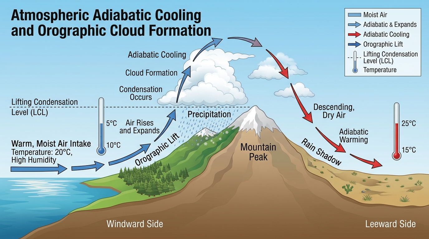
The primary physiological mechanism responsible for tropospheric cloud formation is the adiabatic cooling of moist air as it rapidly ascends through the atmospheric column. As a localized parcel of humid air is subjected to forced vertical lifting, whether driven mechanically by orographic forcing over large mountain ranges, localized convective heating radiating from the surface, wide-scale low-level wind convergence, or aggressive mechanical lifting along synoptic weather fronts, it inevitably encounters progressively lower ambient atmospheric pressure. To successfully maintain physical pressure equilibrium with its changing environment, the rising air parcel rapidly expands. This volumetric expansion requires significant mechanical work to be performed directly against the surrounding air, which rapidly consumes the parcel’s internal thermal energy, thereby dramatically lowering its overall temperature.
When the rising parcel’s temperature successfully cools exactly to its specific dew point, the relative humidity reaches precisely 100 percent, and the air volume becomes totally saturated, meaning the internal vapor pressure perfectly equals the saturation vapor pressure. The specific, calculable altitude at which this saturation is achieved for a parcel lifted dry-adiabatically from the surface is officially identified as the Lifting Condensation Level (LCL). The LCL can be determined graphically on a standard thermodynamic Skew-T plot by strictly following the dry adiabatic lapse rate, which operates at approximately 9.8 °C per kilometer, upward from the surface temperature until it intersects the constant saturation mixing ratio line extending vertically from the surface dew point.
Because the distinct slopes of these two thermodynamic lapse rates differ by approximately 8 K/km, resulting in a physical inversion of roughly 125 meters per Kelvin (125 m/K), meteorologist James Pollard Espy pointed out that the LCL altitude can be mathematically approximated with incredibly high accuracy. The simplified analytical approximation for the LCL height in meters is expressed perfectly by the equation h ≈ 125(T – Td), where T is the initial surface temperature and Td is the surface dew-point temperature. In contrast to the mechanically forced LCL, the Convective Condensation Level (CCL) represents the altitude at which a parcel of air, specifically when heated from below by solar insolation rather than forced upward by a front, will rise dry-adiabatically until it achieves 100 percent humidity. Once a parcel surpasses the Level of Free Convection (LFC), it becomes positively buoyant relative to its environment and will accelerate upward, driving towering cloud formation.
2. Aerosol Microphysics and Nucleation
While adiabatic cooling steadily drives the atmosphere toward thermodynamic saturation, the actual physical phase transition from invisible water vapor to visible liquid droplets is heavily constrained by extreme surface tension. In a hypothetical, perfectly clean atmosphere totally devoid of aerosols, pure water vapor exhibits such incredibly high surface tension that the spherical shape a newly formed water droplet must take is structurally highly unstable, thereby actively resisting condensation. Under these idealized, sterile conditions, homogeneous nucleation (the spontaneous condensation of pure water) would not occur until the relative humidity reached upwards of 120 percent, representing a massive and highly unnatural 20 percent supersaturation.
However, the terrestrial troposphere is replete with minute solid and liquid particles known globally as aerosols, typically measuring about one-hundredth the size of a standard cloud droplet. These particles originate from natural and anthropogenic sources, including wind-blown soil dust, volcanic ash, oceanic sea salt spray, and smoke from combustion. A critical subset of these ubiquitous aerosols are highly hygroscopic, meaning they inherently attract water molecules, and serve optimally as Cloud Condensation Nuclei (CCN). By providing a stable solid surface upon which water vapor can physically deposit, CCN facilitate rapid heterogeneous nucleation. This natural polluting of pure water drastically lowers the thermodynamic barrier, allowing water to condense with much lower values of supersaturation, typically on the order of just a few tenths of a percent, such as 100.1% to 101%.
| Ice Nucleus Type | Temperature Required to Induce Freezing |
|---|---|
| Biological Bacteria | -2.6 °C |
| Vaterite (Mineral) | -9.0 °C |
| Silver Iodide | -10.0 °C |
| Kaolinite (Clay) | -30.0 °C |
| Homogeneous (Pure Water) | -35.0 °C |
The nature of these nuclei becomes even more critical in the formation of solid ice crystals. If the condensation process occurs below the freezing level, pure liquid water will absolutely not spontaneously freeze at 0 °C. For homogeneous nucleation of ice to occur, cloud temperatures would have to plummet to a freezing -35 °C. Therefore, clouds that form just above the freezing level are composed almost entirely of deeply supercooled liquid droplets. To successfully freeze at warmer sub-zero temperatures, the atmosphere relies strictly on specialized aerosols called ice nuclei, which operate via complex contact freezing and immersion freezing pathways.
3. Microphysical Precipitation Mechanisms
For a microscopic cloud droplet to precipitate and successfully reach the Earth’s surface as heavy rain or snow, it must miraculously increase in physical size almost a million times over. Rain droplets absolutely must achieve a substantial terminal velocity, which is the constant downward speed an object reaches when the gravitational force is perfectly balanced by the opposing aerodynamic drag force, in order to successfully overcome the intense convective updrafts that originally produced the cloud. Growth strictly through the continued condensation of water vapor is incredibly slow and highly inefficient, ceasing to be a valid form of growth once the drop achieves a tiny radius of merely 20 μm. Instead, the atmosphere generates precipitable mass through two primary, highly distinct microphysical pathways.
In warm clouds, defined explicitly as clouds located entirely below the atmospheric freezing level where temperatures remain greater than 0 °C throughout their vertical extent, the Collision-Coalescence process is the sole mechanism for precipitation. Larger collector drops, which possess a much higher mass and consequently much higher terminal velocities, fall significantly faster than their smaller counterparts. As they rapidly fall, compressed air beneath the collector drops physically forces them directly into the paths of smaller, slower-moving droplets. If they physically bump into each other and stick together, they merge their liquid mass to form a heavy raindrop capable of breaking through the updraft. This mechanism predominates heavily in tropical maritime environments.
4. The Wegener-Bergeron-Findeisen (WBF) Process
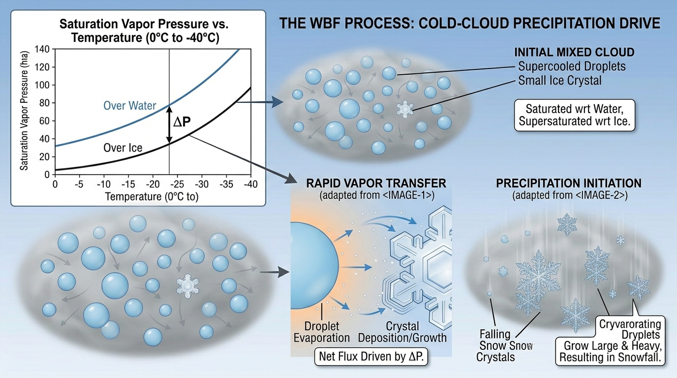
In mid-latitude and polar regions, and at higher elevations globally, convective updrafts frequently carry growing clouds well above the freezing level. These resulting mixed-phase clouds are highly thermodynamically unstable environments containing a chaotic, violent mixture of water vapor, supercooled liquid droplets, and solid ice crystals. Within this sub-freezing environment, the Wegener-Bergeron-Findeisen (WBF) process, also referred to as the cold-rain process, acts as the absolute dominant microphysical pathway for heavy precipitation.
The physical basis of the WBF process is rooted deeply in the thermodynamic reality that the saturation vapor pressure over liquid water is inherently larger than the saturation vapor pressure over solid ice at the exact same sub-freezing temperature. When the ambient vapor pressure of the mixed-phase cloud falls squarely between the saturation pressure of ice and the saturation pressure of liquid water, a massive thermodynamic imbalance occurs. To successfully restore equilibrium, the supercooled liquid droplets rapidly evaporate, releasing vast amounts of water vapor into the ambient air. This increased vapor immediately undergoes rapid deposition directly onto the neighboring ice crystals. Through this continuous vapor transfer, the ice crystals grow at a massively accelerated rate at the direct expense of the evaporating liquid phase, effectively scavenging the water until the liquid droplets are entirely consumed. As the ice crystals grow in mass, their terminal velocity increases until they fall through the base of the cloud, melting into rain if the sub-cloud layer is above freezing.
5. The WMO Classification Architecture
To systematically organize the vast visual and physical diversity of clouds, the World Meteorological Organization (WMO) through the widely respected International Cloud Atlas divides the troposphere strictly into three vertical étages: High, Middle, and Low. The exact limits of these étages overlap and vary significantly depending on latitude due to the differing heights of the tropopause, which is highest at the equator and lowest at the frigid poles.
| Vertical Étages | Representative Genera | Altitude Range (Temperate Regions) |
|---|---|---|
| High Level | Cirrus, Cirrocumulus, Cirrostratus | 5 to 13 km (16,500 to 45,000 ft) |
| Middle Level | Altocumulus, Altostratus, Nimbostratus | 2 to 7 km (6,500 to 23,000 ft) |
| Low Level | Stratus, Stratocumulus, Cumulus, Cumulonimbus | Surface to 2 km (0 to 6,500 ft) |
The fundamental rule of the WMO classification is the strict principle of mutual exclusivity among the ten principal groups, officially termed genera. Every observed cloud in the sky is a member of one, and only one, genus. To achieve granular precision, most genera are further subdivided into specific species based on peculiarities in the shape and internal structure of the cloud. A cloud may bear the name of only one species, meaning the 15 species are mutually exclusive. Conversely, clouds can exhibit varying degrees of transparency and specific geometric arrangements, which are classified as varieties, allowing a single cloud to simultaneously show characteristics of more than one variety.
6. Cirrus (Ci): High-Altitude Ice Filaments
Cirrus (Ci) clouds form in the highest and coldest regions of the troposphere and are completely composed of solid ice crystals or deeply supercooled water droplets. They are defined as detached, highly delicate clouds in the form of white filaments, mostly appearing in thin patches or narrow bands. They possess a distinct fibrous (hair-like) and silky sheen appearance. When Cirrus crosses the solar disk, it hardly diminishes its brightness. Because of their immense altitude, Cirrus are often beautifully colored bright yellow or red before sunrise and after sunset. Cirrus clouds are classified into several highly distinct species, including Cirrus fibratus (nearly straight or irregularly curved white filaments), Cirrus uncinus (comma-shaped hooks terminating in a tuft), Cirrus spissatus (dense patches thick enough to obscure the sun), Cirrus castellanus (small turreted projections), and Cirrus floccus (small tufts with rounded heads and ragged bases).
7. Cirrocumulus (Cc): Patchy Cellular Grains
Cirrocumulus (Cc) appears as a thin, white, patchy sheet or layer arranged somewhat regularly into grains or ripples without any dark shading. A primary identifying factor is the extreme miniaturization of its elements; most of the individual cellular patches have an apparent width of less than one degree (approximately the width of the little finger held at arm’s length). Predominantly made of ice crystals, Cirrocumulus is often short-lived and typically forms in connection with Cirrus or Cirrostratus, or as a degraded state of these clouds. It occasionally produces virga, which is precipitation that completely evaporates aloft before reaching the surface.
8. Cirrostratus (Cs): Halo-Producing Veils
Cirrostratus (Cs) is a transparent, whitish, veil-like cloud that exhibits a fibrous or completely smooth appearance. A sheet of Cirrostratus is very extensive, often covering the entire sky, but it is never thick enough to prevent objects on the ground from casting shadows when the sun is high. While a veil of Cirrostratus may resemble a milky layer of fog, it is definitively distinguished by its unique optical properties: Cirrostratus almost always produces a highly visible halo phenomenon (a 22-degree luminous ring) caused by the massive refraction of the Sun’s or Moon’s rays directly through its ice crystals. Cirrostratus does not produce surface precipitation but acts as a highly reliable forerunner to warm front activity.
9. Altocumulus (Ac): Mid-Level Laminae and Rolls
Mid-level clouds are denoted by the prefix alto- and are primarily composed of water droplets. Altocumulus (Ac) clouds manifest as white or gray patchy sheets or structured layers composed of laminae (plates), rounded masses, rolls, or balls of cotton. The elements are distinctly larger than those of high-altitude Cirrocumulus, with an apparent width of one to five degrees (larger than the little finger and smaller than three fingers held at arm’s length). When a semitransparent patch of Altocumulus passes directly in front of the sun or moon, it can produce a highly colorful corona, which is a colored ring resulting strictly from diffraction, exhibiting red on the outside and blue inside.
10. Altostratus (As): Uniform Gray Sheets
Altostratus (As) presents as a grayish or bluish cloud sheet or layer of striated, fibrous, or uniform appearance that totally or partly covers the sky. It is structurally denser than Cirrostratus; its thicker parts are thin enough to reveal the Sun, but only dimly, as if seen through ground glass, blurring its outline entirely. Crucially, Altostratus is so perfectly smooth and extensive that objects on the ground cast absolutely no shadows, and it never produces halo phenomena. Because of the extreme uniformity of its macroscopic appearance and internal structure, Altostratus is the only genus not subdivided into any species by the WMO.
11. Nimbostratus (Ns): Deep Rain-Bearing Layers
The prefix nimbo- or suffix -nimbus denotes a rain-bearing cloud. Nimbostratus (Ns) is a dark gray, wet-looking cloud layer of tremendous depth. It is almost invariably found rooted in the middle étage, but its vertical extent is so immense that it frequently extends simultaneously into both the low and high étages. The cloud is thick enough to entirely block out the Sun. Nimbostratus forms through the deepening and thickening of an Altostratus cloud along warm or occluded fronts and is strictly associated with continuously falling, widespread rain, snow, or ice pellets of light to moderate intensity. It never produces heavy, showery, convective precipitation.
12. Stratus (St): Featureless Low Ceilings
Low clouds base strictly below 2,000 meters and are generally composed entirely of liquid water droplets. Stratus (St) is a gray-whitish, flat, uniform, and featureless low cloud layer. When a thick fog naturally lifts from the Earth’s surface, the resulting ceiling is immediately classified as a low Stratus cloud. Generally, no significant precipitation falls from Stratus, though it may produce light drizzle or fine snow grains. If the Sun or Moon is visible through a thinning layer of Stratus, its outline remains remarkably clear, unlike the blurred effect of Altostratus.
13. Stratocumulus (Sc): Low-Level Bundles and Fields
Stratocumulus (Sc) presents as gray or whitish patches, fields, rolls, or bundles with rounded edges. Unlike the perfectly smooth veil of Stratus, Stratocumulus elements are regularly arranged and incredibly massive, possessing an apparent visual size of 5 to 10 degrees (roughly the width of a full hand held at arm’s length). Stratocumulus rarely yields precipitation. These clouds are typically non-convective or limited-convective, forming securely beneath stable atmospheric inversions.
14. Cumulus (Cu): Free Convection and Fair-Weather Heaps
Cumuliform clouds are actively driven by vigorous free convection, forming precisely when warm, highly buoyant, humid air rises rapidly through cooler surrounding air. Cumulus (Cu) clouds are detached, dense clouds resembling heaps or stacks of cotton balls with flat bases and billowing tops. The WMO meticulously categorizes the lifecycle of Cumulus into a strict sequence of evolving species. It begins with Cumulus humilis, small, flattened fair-weather clouds displaying minimal vertical extent. If atmospheric instability persists, they grow into Cumulus mediocris, displaying moderate vertical development reaching up to 3,000 meters. The advanced stage is Cumulus congestus (towering cumulus), which reaches extremely high into the troposphere, resembles a massive cauliflower, and is the only Cumulus species capable of generating significant rain showers.
15. Cumulonimbus (Cb): Towering Thunderstorms and Anvils
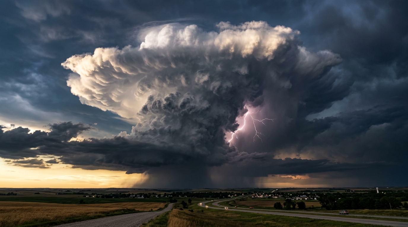
Evolving directly from Cumulus congestus, the Cumulonimbus (Cb) is the ultimate expression of atmospheric instability. It is an exceptionally massive, towering storm cloud capable of producing torrential rain, continuous lightning, hail, and tornadoes. The genus is subdivided by the glaciation of its peak. Cumulonimbus calvus represents the transitional stage where the uppermost protuberances begin to lose their crisp, billowing outlines, becoming smooth and bald as supercooled droplets begin to freeze. The fully mature stage is Cumulonimbus capillatus, where the upper section entirely glaciates into ice crystals, creating a massive, fibrous, hair-like structure that frequently spreads out horizontally against the stable tropopause layer to form the classic thunderstorm anvil (incus).
16. WMO Varieties and Supplementary Features
While species strictly dictate internal structure, the WMO provides 9 specific varieties to accurately describe the geometric arrangement and transparency of cloud elements, alongside 11 supplementary features to describe attached macroscopic physical anomalies. Notable varieties include intortus (irregularly curved, entangled filaments), vertebratus (bands arranged like a skeletal spine), undulatus (broad, parallel, wave-like undulations), radiatus (parallel bands converging at the horizon), and lacunosus (a layer marked by circular holes resembling a net).
Common supplementary features add highly specific visual detail to the genera. A particularly striking feature is mamma (Mammatus clouds), which are incredibly distinct cellular pouches or massive sacs hanging downward directly from the base of a cloud, usually a Cumulonimbus anvil. Mammatus pouches are violently generated by extreme vertical gradients of temperature and moisture exactly when cold, hydrometeor-laden air sinks rapidly directly into the much warmer, drier sub-cloud layer.
17. The 2017 International Cloud Atlas Additions
In 2017, the WMO executed the absolute first major update to the International Cloud Atlas in decades, highly integrating several classifications driven largely by passionate citizen-scientist observations. The most famous addition is Asperitas, formalized as a supplementary feature characterized by exceptionally well-defined, wave-like structures situated in the underside of a cloud base. Unlike a uniform rippling variety, Asperitas is highly chaotic, with localized waves rapidly descending into sharp points, creating a visual effect identical to viewing a roughened sea surface from below.
Other vital additions include Cavum (colloquially known as a fallstreak hole), a well-defined circular clearing within a thin layer of supercooled water droplets that forms when droplets abruptly freeze and fall out as virga. The WMO also introduced Fluctus, which formally adopts the Kelvin-Helmholtz instability wave, appearing as a short-lived, rapidly breaking wave akin to ocean surf. Finally, Volutus was introduced as a wholly new species, representing a distinct, extremely low, horizontal, tube-shaped cloud mass that remarkably appears to smoothly roll along a horizontal axis, completely independent of any parent cloud.
18. Diurnal Cycles and Spatio-Temporal Climatology
The massive generation, spatial fraction, and vertical stratification of global cloud cover are profoundly modulated directly by the diurnal (daily) cycle of solar insolation and subsequent nocturnal radiative cooling. Extensive climatological studies utilizing active satellite lidar data from the Cloud-Aerosol Transport System (CATS) and the CALIPSO satellite reveal massive spatio-temporal discrepancies in cloud behavior perfectly split between landmasses and the open ocean.
Over summer tropical and mid-latitude continental regimes, intense surface heating drives vigorous daytime instability. Consequently, low-level cumuliform clouds build steadily throughout the morning, reaching their maximum spatial occurrence at approximately 2.5 km above sea level in the early afternoon (around 14:00 Local Time). Conversely, the maritime oceanic regime operates almost entirely out of phase, exhibiting an approximate 12-hour lag. Over vast swaths of the global ocean, marine Stratocumulus decks are actively maintained heavily by cloud-top radiative cooling. During the dark night, extreme longwave radiation rapidly escapes from the cloud top into space, cooling the layer and generating sinking parcels that pull moisture upward. Consequently, oceanic cloud fraction and thickness reach their absolute maximum strictly during the night and early morning, completely thinning out as the sun rises and breaks the convective cycle.
19. Synoptic Scale Frontal Progression
On broader multi-day temporal scales, specific cloud chronologies operate as highly reliable macroscopic indicators of synoptic-scale baroclinic boundaries, known formally as weather fronts. A warm front is established when a warm, less dense air mass gradually advances, perfectly overriding a retreating wedge of denser, colder air. Because the isentropic lifting is incredibly slow and gentle, it produces a vast, horizontally expansive shield of stratiform clouds. The visual progression is unmistakable: high-level Cirrus appear up to 24 hours prior, subsequently thickening into a continuous veil of Cirrostratus, lowering deeply into Altostratus, and finally morphing into a thick, dark Nimbostratus layer delivering prolonged, steady rain.
In stark contrast, a cold front occurs when a fast-moving, high-density polar air mass aggressively bulldozes its way directly beneath an unstable, warm air mass. This incredibly aggressive wedging forces the ambient warm air upward with explosive vertical momentum. The violent ascent rapidly pushes the moist air past the Level of Free Convection, immediately bypassing the gentle stratiform phases to instantly generate a highly dense, linear squall line of towering Cumulonimbus clouds exactly along the boundary, characterized by abrupt, dramatic weather shifts including heavy squally precipitation and intense lightning.
20. Upper Atmospheric Cloud Formations
While the absolute vast majority of moisture is perfectly confined to the troposphere, extreme thermodynamic conditions can force nucleation deeply in the stratosphere and mesosphere. Situated between 15 km and 30 km in altitude, the stratosphere is exceptionally dry. However, during the prolonged darkness of the southern polar winter, the massive polar stratospheric vortex actively allows temperatures to plunge drastically below -78 °C. These frigid conditions catalyze the formation of Polar Stratospheric Clouds (PSCs).
Type 1 PSCs are formed through the co-condensation of water vapor and highly toxic nitric acid onto stratospheric sulfuric acid aerosols. Critically, these specific clouds are the primary mechanical driver of polar stratospheric ozone depletion. They brilliantly provide the exact physical crystalline surfaces required to catalytically convert benign chlorine into highly reactive chlorine radicals. When localized temperatures drop even further below -85 °C, pure ice crystals crystallize rapidly to form Type 2 Nacreous Clouds. Because their spherical ice crystals are universally tiny and highly uniform, they undergo massive physical diffraction, beautifully producing brilliant, widespread iridescence. Even higher, near 85 km, Noctilucent clouds form explicitly around suspended meteoric smoke, remaining beautifully illuminated against the dark night sky because their immense altitude keeps them bathed in direct sunlight while the lower troposphere is plunged into deep shadow.
21. Anthropogenic and Anomalous Formations
Human activity and extreme meteorological perturbations regularly produce highly anomalous cloud structures. The Pyrocumulonimbus (PyroCb), officially designated as Cumulonimbus flammagenitus, is a highly energetic convective storm generated entirely by the localized thermal perturbation of a massive surface heat source, such as a severe wildfire or nuclear detonation. As the aerosol-laden smoke plume ascends and breaches the LCL, it violently releases latent heat, building a massive Cumulonimbus architecture capable of producing localized dry lightning and aggressively injecting massive volumes of black carbon aerosols directly into the lower stratosphere, completely altering global radiative forcing.
Similarly, the modern aviation industry induces direct modifications to upper-tropospheric cloud cover through the formation of persistent contrails, formally classified as Cirrus homogenitus. When an aircraft exhaust plume penetrates an Ice Supersaturated Region (ISSR), the ejected soot provides the necessary Cloud Condensation Nuclei for ambient vapor to freeze. Under high wind shear, these contrails spread horizontally over several hours, transitioning into vast, artificial cirrus shields (Cirrus homomutatus). Because these high-level ice clouds are highly opaque to outgoing longwave terrestrial radiation, the massive proliferation of persistent contrails results in a strong net-positive radiative forcing, definitively making them a major non-CO2 contributor to aviation-induced global warming. Lastly, the incredibly rare Horseshoe vortex cloud forms when a weak thermal updraft ascends into a layer of strong horizontal wind shear, capturing the updraft in a horizontal dipole vortex that bends the condensing air into a distinct U-shape before rapidly evaporating.