The El Niño-Southern Oscillation (ENSO) stands as the single most influential natural climate pattern on Earth, driving profound interannual variability within the global atmospheric and oceanic circulation systems. Operating primarily within the vast expanse of the equatorial Pacific Ocean, ENSO is an irregularly cyclical phenomenon that fundamentally dictates temperature, precipitation, and atmospheric pressure paradigms across the planet. As a highly coupled ocean-atmosphere system, the oscillation fluctuates dynamically between three distinct phases: El Niño (the warm phase), La Niña (the cool phase), and ENSO-neutral conditions. By alternately warming and cooling immense stretches of the tropical Pacific, ENSO redistributes the primary zones of moist, rising air masses.
This monumental relocation of thermal energy acts as an atmospheric boulder in a stream, displacing the global circulation patterns that connect the tropics to the middle and high latitudes, thereby forcing widespread alterations in the planetary jet streams. The societal, ecological, and economic implications of these planetary-scale fluctuations are almost without parallel in the natural world. Historical ENSO events have triggered catastrophic famines, accelerated the transmission of infectious diseases, decimated marine ecosystems, disrupted global agricultural markets, and caused economic damages extending into the tens of billions of dollars.
The Global Climatic Architect
El Niño and La Niña are powerful reminders of how interconnected our planet truly is. It is incredible that shifting ocean temperatures in the Pacific can simultaneously cause droughts in Australia, floods in Peru, and even alter the path of hurricanes in the Atlantic. These climate patterns ripple across continents, showing that a single change in one part of the world can reshape weather systems everywhere.
Understanding El Niño and La Niña is vital not just for scientists but for global agriculture, economics, and human survival. Farmers depend on predictable rainfall, economies rely on stable supply chains, and communities need protection from extreme weather. These patterns are more than natural curiosities—they are forces that shape food security, trade, and daily life across the globe.
| ENSO: Climate Profile & Forecast | |
|---|---|
| Primary Region | Equatorial Pacific Ocean |
| Climate Phases | El Niño, La Niña, and ENSO-Neutral |
| Atmospheric Cell | The Walker Circulation |
| Primary Mechanism | The Bjerknes Feedback loop |
| Monitoring Zone | Niño 3.4 region (5°N to 5°S and 170°W to 120°W) |
| Emerging Variant | ENSO Modoki (Central Pacific warming) |
| Global Teleconnections | Atmospheric Rossby waves displacing jet streams |
| 2026 Summer Forecast | 80% probability of El Niño development |
| Deadliest Historic Event | The Great Famine (1877 to 1878) killing 12 to 29 million |
| Pandemic Correlation | La Niña linked to all 4 major human influenza pandemics since 1918 |
1. Ocean-Atmosphere Coupling and Fundamental Mechanisms
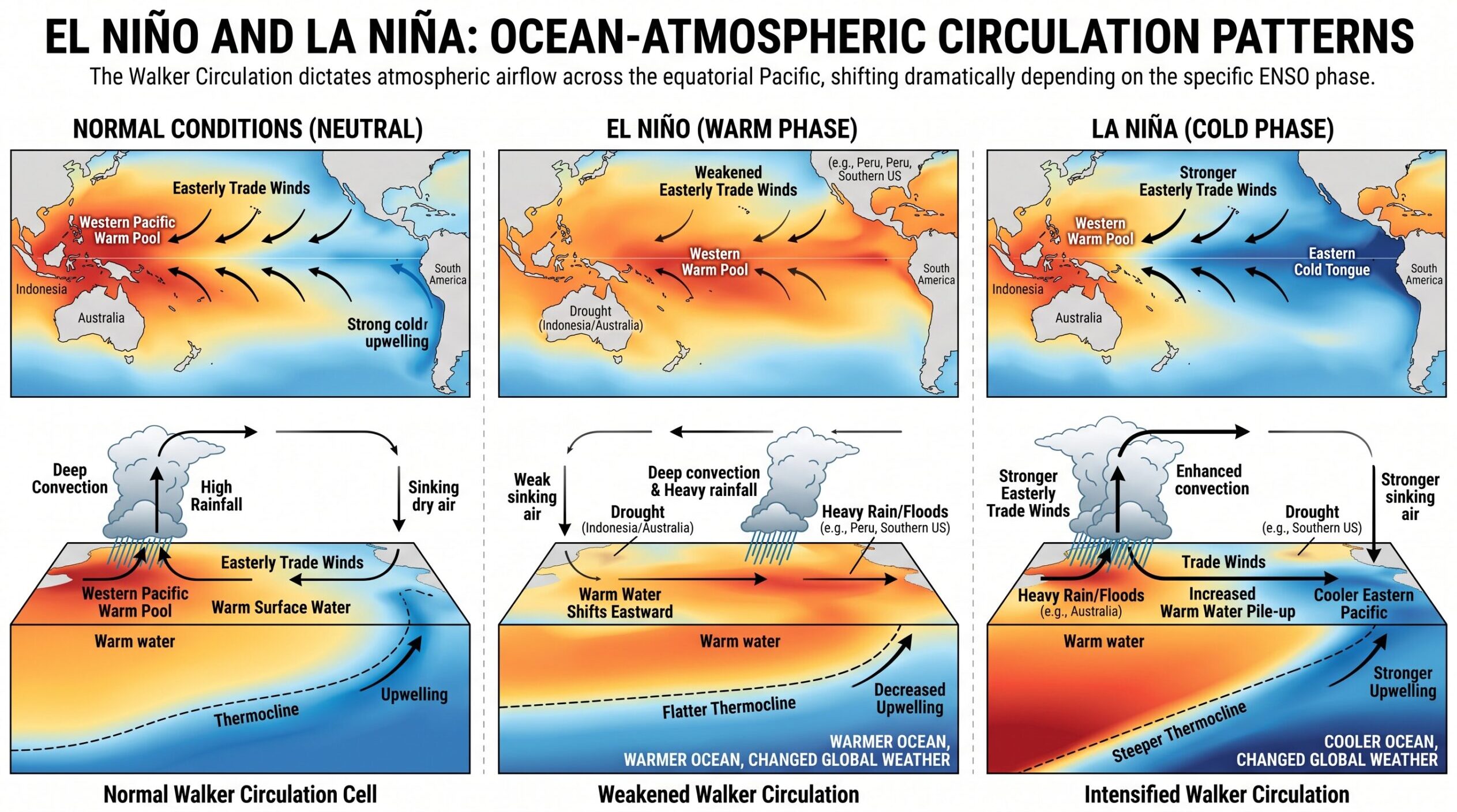
The architecture of ENSO is entirely dependent upon a delicate, continuous interaction between the ocean and the atmosphere. Without this synchronized feedback loop, the oscillation would simply cease to exist, and predicting seasonal climate anomalies would be rendered virtually impossible. Under normal, or ENSO-neutral conditions, the prevailing easterly trade winds blow persistently across the equatorial Pacific Ocean from east to west. The mechanical force of these planetary winds continuously pushes warm, sun-heated surface waters toward the western Pacific, pooling them near Indonesia, the Philippines, and northern Australia. Because of this persistent westward transport, sea levels in the western Pacific are elevated by approximately 0.5 meters relative to the eastern Pacific near the coast of South America.
To replace the massive volume of surface water displaced to the west, cold, nutrient-dense water from the deep ocean rises to the surface along the South American coast, a vital oceanic process known as equatorial upwelling. This dynamic creates a steeply sloped thermocline, which is the oceanic transition layer separating the warm, well-mixed surface waters from the frigid deep-ocean abyss. Under ENSO-neutral conditions, the thermocline sits at a depth of roughly 140 meters in the western Pacific but is pushed much closer to the surface in the eastern Pacific.
2. The Walker Circulation and the Bjerknes Feedback
The atmospheric counterpart to this oceanic temperature gradient is the Walker Circulation, an east-west overturning atmospheric cell named after Sir Gilbert Walker. While working in India between 1903 and 1923, Walker observed massive, hemispheric swaying of atmospheric pressure between the Pacific and Indian Oceans, which he termed the Southern Oscillation. Decades later, scientist Jacob Bjerknes utilized early satellite data to mathematically link Walker’s Southern Oscillation with the oceanic sea surface temperatures (SST), fully defining the coupled ENSO system.
The Walker Circulation operates efficiently during neutral conditions. The deep pool of warm water in the western Pacific aggressively heats the overlying atmosphere, causing the air to rise, condense, and produce torrential precipitation over Indonesia and the western Pacific. Once aloft, the air travels eastward in the upper troposphere, cools, and descends over the colder waters of the eastern Pacific, creating a persistent zone of high atmospheric pressure. The air then completes the circuit by flowing westward back across the surface as the easterly trade winds. This relationship is governed by the Bjerknes feedback, a positive feedback mechanism wherein an initial alteration in the sea surface temperature gradient changes the atmospheric pressure gradient. This pressure shift subsequently modifies the strength of the trade winds, which in turn drives further changes in ocean currents and upwelling, creating a self-amplifying loop of climate anomalies.
3. The Dynamics of Genesis: El Niño and La Niña
During the genesis of an El Niño event, the easterly trade winds weaken across the equatorial Pacific, and in extreme cases, completely reverse to become westerly wind bursts. The Bjerknes feedback acts to depress and fracture the Walker Circulation. Without the relentless driving force of the trade winds, the elevated pool of warm water in the western Pacific collapses and surges eastward across the ocean basin. This suppresses the upwelling of cold water along the Americas and deepens the eastern thermocline. Consequently, the primary zone of convection shifts from Indonesia toward the central or eastern Pacific, dragging massive precipitation systems with it. This atmospheric reorganization results in anomalous high pressure over Indonesia, Australia, and the Indian Ocean, and abnormally low pressure over the eastern Pacific.
Conversely, La Niña represents a hyper-intensification of the normal climatological state. During this phase, the easterly trade winds blow with exceptional and anomalous vigor, pushing even greater volumes of warm water to the extreme western Pacific while intensifying the upwelling of cold water in the east. The thermocline becomes extraordinarily steep, and the eastern Pacific experiences pronounced cooling. The Walker Circulation strengthens significantly, resulting in enhanced, often catastrophic convection and precipitation over the western Pacific and Indonesia, while the eastern Pacific is dominated by rigid high-pressure systems and severe aridity. To monitor these phases, meteorological agencies utilize indices such as the Oceanic Niño Index (ONI), focusing heavily on the Niño 3.4 region, a specific swath of the equatorial Pacific located between 5°N to 5°S and 170°W to 120°W.
4. The Dichotomy of Flavors: Canonical versus Modoki ENSO
While historical meteorological understanding centered entirely on sea surface temperature anomalies in the far eastern Pacific, contemporary climatology has identified a distinct, increasingly frequent variation of the phenomenon known as ENSO Modoki. Derived from the Japanese language, the term Modoki translates to a similar but different thing, accurately capturing the deceptive nature of this climate variant.
The traditional, or Canonical El Niño, is characterized by maximum anomalous warming concentrated firmly in the eastern equatorial Pacific, accompanied by cold anomalies in the extreme western Pacific. In stark contrast, El Niño Modoki (frequently referred to as Date Line El Niño or Central Pacific El Niño) features anomalous warming primarily located in the central equatorial Pacific. This central warming is flanked by cooler sea surface temperature anomalies to both the east and the west, creating a distinct zonal tripole pattern.
| Modoki Classification | SST Anomaly Distribution | Atmospheric Circulation Impacts | Regional Precipitation & Cyclone Steering |
|---|---|---|---|
| El Niño Modoki I | Symmetric distribution about the equator. Maximum warming originates strictly in the equatorial central Pacific. | Induces an anomalous anticyclone in the Philippine Sea and extends the Western North Pacific Subtropical High westward. | Generates southwesterly wind anomalies that carry heavy moisture to southern China, increasing autumn rainfall. Associated with neutral/positive typhoon steering. |
| El Niño Modoki II | Asymmetric distribution. Warm anomalies originate in the subtropical northeastern Pacific and extend into the equatorial central Pacific. | Resides as an anomalous cyclone east of the Philippines. Forces the Western North Pacific Subtropical High to shift eastward. | Induces northerly wind anomalies that decrease rainfall in southern China. Creates northwesterly steering flows that actively prevent typhoons from making landfall in East Asia. |
The spatial reorganization of the SST-induced diabatic heating fundamentally alters global atmospheric teleconnections, frequently producing impacts that are entirely antithetical to a Canonical event. For example, while a Canonical El Niño reliably brings enhanced precipitation to the West Coast of the United States, an El Niño Modoki frequently plunges the exact same region into drought. The frequency of Modoki events has increased substantially since 1990, suggesting that anthropogenic climate forcing may be altering the baseline spatial dynamics of the tropical Pacific.
5. Global Teleconnections and Inter-Basin Interactions
ENSO’s unparalleled capacity to dictate global weather patterns is executed through teleconnections, atmospheric bridge mechanisms wherein localized changes in tropical oceanic heat release propagate as planetary-scale Rossby waves, disrupting the mid-latitude jet streams. Because these atmospheric pathways operate similarly to boulders disrupting a fast-flowing stream, they displace storm tracks, lock stationary high-pressure ridges in place, and alter hemispheric weather thousands of miles from the equator.
In the North Atlantic and European region, ENSO teleconnections are remarkably complex and heavily modulated by competing regional patterns, such as the North Atlantic Oscillation and the Tropical North Atlantic. Interestingly, the presence of a strong ENSO event significantly improves the accuracy of European winter weather forecasts. The robust tropical forcing associated with a strong El Niño or La Niña effectively overrides localized atmospheric noise, allowing meteorological agencies to issue highly confident seasonal predictions.
The relationship between ENSO and the Indian Ocean Dipole (IOD) adds a critical layer of complexity. Historically, extreme IOD events produce massive convective diabatic heating anomalies that feed directly back into the Walker circulation, actively altering the evolution, onset, or decay of an ENSO event. Recent coupled ocean-atmosphere modeling has revealed that a positive IOD can induce both warm and cold sea surface temperature anomalies in the Pacific. Specifically, when a positive IOD coincides with localized warming in the Seychelles-Chagos thermocline ridge, it forces La Niña-like conditions in the tropical Pacific through an atmospheric bridge process known as the warm pool dipole.
6. Global Climatological and Meteorological Impacts
The translation of these atmospheric waves into localized weather phenomena produces starkly contrasting realities depending on the geographic region and the phase of the oscillation. In the United States, the impacts of ENSO are most pronounced during the boreal winter months. During a standard El Niño, the subtropical jet stream is significantly enhanced and shifts southward. This atmospheric realignment results in persistently wetter and cooler conditions across the southern tier of the United States, from Southern California across Texas and into the Gulf Coast. Concurrently, the northern United States and Canada tend to experience abnormally mild and dry winters, which often results in dramatically reduced winter heating costs. Conversely, a La Niña winter forces the jet stream northward, leaving the southern U.S. abnormally warm and dry while the Pacific Northwest faces wetter, colder, and snowier conditions.
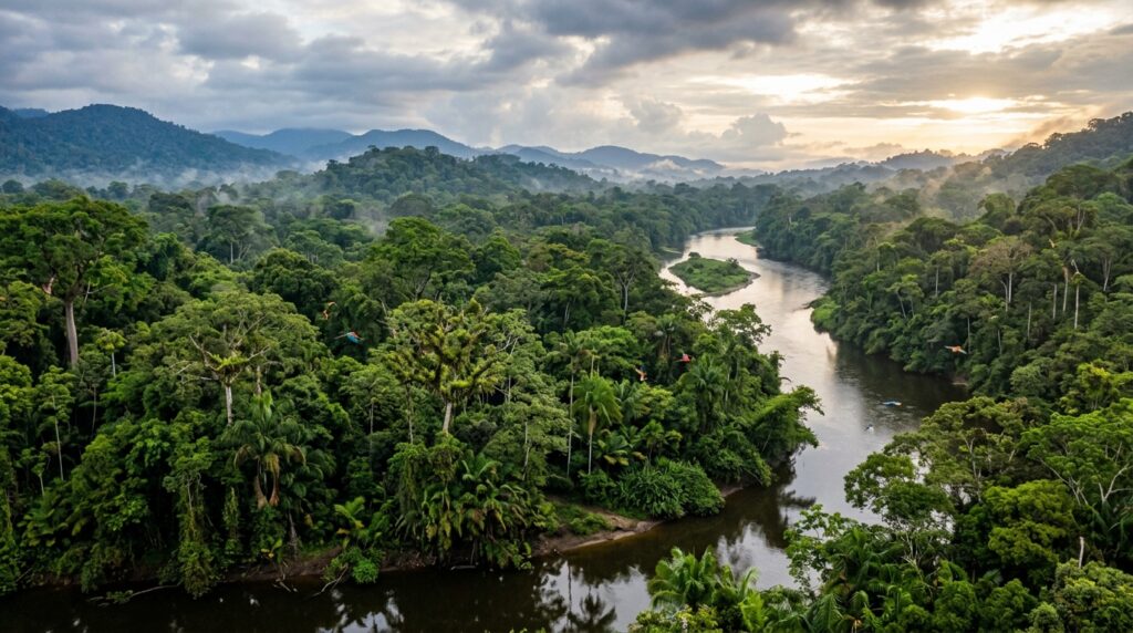
In South America, ENSO acts as the primary climate conductor. El Niño typically delivers plentiful, reliable spring and summer rainfall to central Argentina, Uruguay, and southeastern Brazil. However, the same phase frequently brings catastrophic, infrastructure-destroying flooding to the coastal deserts of Peru and Ecuador, while subjecting northern South America and the Amazon basin to severe, prolonged droughts. During La Niña, this paradigm flips entirely; the La Plata Basin experiences intense, multi-year droughts that deplete regional water storage to critically low levels.
In Australia and Asia, La Niña is synonymous with extensive, and sometimes devastating, precipitation. Even weak La Niña events heavily promote vegetation growth across China and Australia, while intense events drive massive, rapid greening across Australia’s normally arid interior. Conversely, El Niño is closely linked to widespread drought and extreme heatwaves across Indonesia, Southeast Asia, and eastern Australia, elevating the risk of catastrophic bushfires. Furthermore, the vertical wind shear generated by ENSO phases directly governs global tropical cyclone activity. During El Niño, enhanced upper-level westerly winds increase vertical wind shear across the tropical Atlantic basin, effectively decapitating developing tropical waves and leading to a largely suppressed Atlantic hurricane season.
7. Ecological and Marine Devastation
The suppression of equatorial upwelling during El Niño deprives surface waters of essential nitrates and phosphates, triggering severe trophic cascades in marine environments. Perhaps nowhere is this more visceral than in the Galápagos Islands, an archipelago positioned almost perfectly on the equator at the absolute epicenter of ENSO anomalies. During the catastrophic 1982 to 1983 El Niño, the Galápagos experienced an ecological wipeout. The suppression of cold, nutrient-rich water caused red and green algae to vanish entirely. Consequently, Galápagos marine iguanas experienced up to 67% mortality in some colonies, penguin populations crashed by 77%, all territorial male fur seals perished, and massive fractions of booby populations died from starvation within a matter of months.
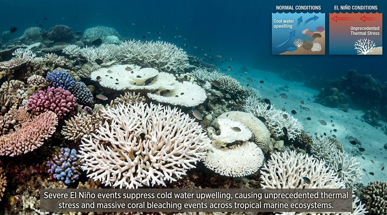
A similar trophic collapse frequently occurs off the coast of Peru, where warmer waters drive cold-water anchovies away, devastating local fishing fleets and crippling the global production of fishmeal. Furthermore, El Niño-induced thermal stress is the primary instigator of mass global coral bleaching events. The 2014 to 2017 global bleaching event, severely accelerated by the strong 2015 to 2016 El Niño, became the longest, most widespread, and most damaging coral bleaching event in recorded history. Unprecedented heat stress accumulated rapidly, causing mass bleaching and mortality in pristine reefs that had never previously bleached, such as the northernmost sectors of the Great Barrier Reef.
8. Agricultural Yields, Food Security, and Viticulture
The ENSO system dictates the baseline of global agricultural productivity. During major ENSO events, global crop yields (specifically wheat, maize, and soy) frequently fall 2% to 4% below expected baselines. Therefore, a 2% to 4% baseline reduction driven by ENSO, when compounded by structural or economic vulnerabilities, is sufficient to trigger widespread famine. The historical record grimly demonstrates this reality: the world food crisis of 1982 to 1984, the most severe in modern records which caused immense famine in the Horn of Africa and the Sahel, was directly linked to El Niño. During the recent triple-dip La Niña, Argentina’s 2022 to 2023 soybean yield dropped from a baseline of 43.90 million tons to a mere 25 million tons, a historic 43% collapse that sent shockwaves through global agricultural commodity markets.
| Major Wine Producing Region | Projected Production Decline by 2050 (Under Severe Warming & ENSO Shifts) |
|---|---|
| Bordeaux, Rhone, and Tuscany (Europe) | 85% decrease in suitable production areas. |
| Australia | 74% decrease in suitable production areas. |
| California (United States) | 70% decrease in suitable production areas. |
| Cape Region (South Africa) | 55% decrease in suitable production areas. |
| Chile | 40% decrease in suitable production areas. |
Viticulture is exceptionally sensitive to the subtle climatological shifts induced by ENSO. Climate modeling indicates that shifts in temperature and moisture driven by ENSO teleconnections will drastically alter the global geography of wine production by 2050. As traditional coastal and low-altitude regions in southern Europe and California become hostile to viticulture, vineyards may be displaced more than 1,000 kilometers beyond their traditional boundaries, allowing regions like British Columbia and Denmark to emerge as new frontiers for global wine production.
9. Epidemiological Dynamics and Disease Outbreaks
The intersection of ENSO and human health is intricately mediated by the availability of surface water and the modulation of ambient temperatures, which directly govern the lifecycles and habitats of vectors and pathogens. In arid regions, intense ENSO-driven rainfall creates stagnant water puddles, while in wet regions, ENSO-driven droughts reduce flowing rivers to isolated, stagnant pools. Both scenarios provide optimal breeding grounds for mosquitoes, triggering massive malaria, dengue, chikungunya, and Zika epidemics in South America, South Asia, and Africa. Beyond vector-borne illness, the lack of clean water during ENSO droughts forces populations to consume unsafe water, directly facilitating horrific cholera outbreaks.
Perhaps the most startling epidemiological hypothesis relates ENSO to the emergence of novel, pandemic-grade influenza strains. A retrospective analysis reveals that the last four major human influenza pandemics (1918, 1957, 1968, and 2009) were all immediately preceded by distinct La Niña conditions. Because ENSO dictates temperature, precipitation, and storm tracking, it deeply influences the flight paths, stopover times, and biomass of migratory birds (the primary reservoir of influenza A viruses). The prevailing scientific hypothesis suggests that La Niña conditions force divergent avian populations to congregate in restricted geographic flyways. This forced, dense interspecies mixing facilitates the simultaneous multiple infection of individual hosts, providing the perfect biological crucible for the genetic reassortment of influenza virus gene segments and the subsequent generation of highly novel pandemic strains.
10. A Historical Anthology of Extreme ENSO Events
Understanding the statistical envelope and destructive potential of ENSO requires analyzing its most extreme historical manifestations across the past 150 years.
- The Great Famine of 1877 to 1878: Widely considered one of the most devastating humanitarian disasters in recorded history, the Great Famine killed an estimated 12 to 29 million people across India, China, Brazil, and Africa. Recent paleoclimatology confirms that an exceptionally fierce El Niño event was the primary driver. A prolonged period of coolness allowed massive amounts of warm water to accumulate in the western Pacific, discharging violently into a strong El Niño where the Niño-3 index may have reached a staggering 3.5°C.
- The 1918 to 1919 Event: Modern supercomputer modeling utilizing the 20th Century Reanalysis Project has revealed that the 1918 to 1919 El Niño was actually one of the strongest of the 20th century. This intense climatic disruption aligns perfectly with the devastating 1918 flu pandemic, further supporting the epidemiological reassortment hypothesis.
- The 1997 to 1998 Event: Widely recognized as the first broadly forecasted broadcast El Niño, this event caused an estimated global economic loss of between $32 billion and $96 billion. It triggered massive forest fires in Indonesia, severe droughts in Central America, and catastrophic flooding in Peru.
- The 2015 to 2016 Event: A super El Niño that rivaled the 1997 anomaly, it recorded a +2.6°C SST anomaly in the Niño 3.4 region. It initiated the devastating Third Global Coral Bleaching event, caused severe drought affecting 60 million people in Latin America, and exacerbated rampant forest fires in Southeast Asia.
- The 2020 to 2023 “Triple-Dip” La Niña: A remarkably rare occurrence where La Niña conditions persisted for three consecutive years. In the past 50 years, this has only occurred three times. It drastically prolonged the severe drought in the La Plata basin, bringing Uruguay’s water reservoirs to critically low levels, while simultaneously driving historic, unrelenting flooding in parts of Asia and eastern Australia.
11. Dispelling Common Meteorological Fallacies
Given the profound global impacts of ENSO, public discourse is frequently saturated with oversimplifications and meteorological fallacies. Resolving these misconceptions is vital for accurate risk assessment. For instance, a common myth is that El Niño directly strikes the United States; however, neither El Niño nor La Niña ever physically comes to North America. They are strictly equatorial Pacific ocean-atmosphere phenomena, and their effects in the mid-latitudes are solely the result of atmospheric teleconnections.
Furthermore, much of the media coverage focuses entirely on the extreme negative consequences, implying all impacts are negative. While extreme events cause disaster, ENSO also confers distinct regional benefits. El Niño reliably suppresses destructive Atlantic hurricane formation, delivers plentiful rain to the agricultural basins of Argentina, and significantly reduces winter heating costs across the northern United States due to milder winter temperatures. Finally, it is scientifically inaccurate to attribute a single storm, tornado outbreak, or specific hurricane directly to El Niño or La Niña. ENSO alters the background atmospheric state, increasing the probability, frequency, and intensity of specific weather types, but localized weather is ultimately dictated by synoptic-scale meteorology. Both phases harbor severe, life-threatening risks; El Niño is not inherently more dangerous than La Niña.
12. The Anthropogenic Influence: ENSO in a Warming Climate
The intersection of anthropogenic global warming and the natural ENSO cycle presents one of the most critical frontiers in modern climate science. Highly specialized modeling indicates that the impacts and the extremes of the events are rapidly evolving. Climate change acts as a severe atmospheric multiplier. Even if the absolute sea surface temperature anomalies of a modern El Niño remain within historical physical bounds, the baseline temperature of the Earth has risen significantly. Therefore, the combination of an El Niño heat pulse atop anthropogenically elevated global temperatures guarantees that future El Niño events will reliably shatter global heat records.
Furthermore, advanced climate models run under future greenhouse-gas forcing scenarios project a definitive increase in the frequency of consecutive, multi-year La Niña events. The thermodynamic mechanism driving this shift involves a slower oceanic heat recharge, facilitating the persistence of cold anomalies from a first-year La Niña into a second year. Consequently, the prolonged droughts and infrastructure-destroying floods associated with multi-year La Niñas are highly likely to become more frequent phenomena in the twenty-first century. Regarding extreme El Niño events, climatological research suggests their frequency could essentially double, shifting from approximately one every 20 years to one every 10 years by the end of the century. The warming climate also threatens to homogenize historically distinct regional teleconnections, meaning the historically reliable suppression of Atlantic hurricanes during El Niño years may become significantly less distinct as the oceans continue to warm.
13. Current Diagnostic Status and 2026-2027 Strategic Forecast
As of mid-April 2026, the global climate system finds itself at a critical meteorological inflection point, officially transitioning out of the weak La Niña conditions that dominated late 2025 and early 2026. A comprehensive analysis of the current oceanic and atmospheric state indicates a high-probability trajectory toward a robust El Niño phase by the boreal summer of 2026.
As of March and early April 2026, the weekly Niño-3.4 index values fluctuated near the neutral baseline, registering at -0.0°C to -0.2°C. While the sea surface temperatures in the east-central equatorial Pacific currently represent textbook ENSO-neutrality, the underlying oceanic heat content reveals a rapidly developing and highly energetic narrative. The equatorial subsurface temperature index has increased consistently for five consecutive months, and a massive volume of above-average subsurface heat is actively expanding eastward toward the South American coast. Concurrently, crucial westerly wind anomalies have emerged over the western equatorial Pacific at low levels. These westerly wind bursts are actively counteracting the normal easterly trade winds, providing the exact mechanical momentum necessary to force the warm subsurface waters to the surface, instigating the Bjerknes feedback loop required for El Niño genesis.
| Forecast Season (2026 to 2027) | ENSO-Neutral Probability | El Niño Probability | La Niña Probability |
|---|---|---|---|
| MAM (Mar to May 2026) | 91% | 9% | 0% |
| AMJ (Apr to Jun 2026) | 53% | 47% | 0% |
| MJJ (May to Jul 2026) | 28% | 72% | 0% |
| JJA (Jun to Aug 2026) | 20% | 80% | 0% |
| JAS (Jul to Sep 2026) | 23% | 76% | 1% |
| ASO (Aug to Oct 2026) | 21% | 78% | 1% |
| NDJ (Nov to Jan 2026/27) | 22% | 73% | 5% |
Consensus among the world’s premier meteorological agencies aligns heavily toward imminent El Niño development. By the May to July 2026 season, El Niño probabilities rise to 61% to 72%, officially replacing neutral conditions as the most likely climatological state. The objective models predict that El Niño will reach its peak likelihood of 80% during the June to August 2026 window, maintaining dominance throughout the remainder of 2026 and extending well into the January 2027 season. The probability of La Niña redeveloping during this timeframe remains statistically negligible, staying under 5% through early 2027.
Adding significantly to the complexity and danger of the 2026/2027 forecast is the concurrent trajectory of the Indian Ocean Dipole. Current models heavily favor the development of positive IOD conditions by the second half of 2026, with probabilities exceeding 60% from July to September. The simultaneous development of a positive IOD and an El Niño guarantees severe and compounding teleconnection impacts, specifically regarding the rapid intensification of drought in Australia and Indonesia, and dramatically enhanced rainfall across the western Indian Ocean basin and the Horn of Africa.